| Port/s | Vietnam |
| Issue Type | Natural disaster |
| Impact | Complete Closure |
Typhoon Kalmaegi entered the East Sea early on Wednesday after crossing the central Philippines, maintaining maximum sustained winds of 134–149 kph.
The storm is forecast to strengthen further to 150–166 kph on Thursday as it approaches the waters off Vietnam’s south-central coast, stretching from Da Nang to Khanh Hoa, home to Nha Trang.
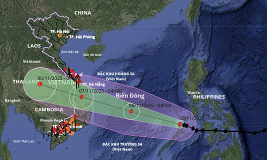
The National Centre for Hydro-Meteorological Forecasting (NCHMF) reported that Kalmaegi, the 13th storm to affect Vietnam this year, was about 510 km from Song Tu Tay in the Truong Sa (Spratly) Islands at 6 a.m. on Wednesday. It was moving west-northwest at 20–25 kph with maximum winds of 149 kph.
The NCHMF projects the typhoon will reach its peak intensity of 166 kph by 4 a.m. on Thursday, at which point its centre will be approximately 550 km from the coast of Gia Lai Province. It is expected to continue moving west-northwest, accelerating to 25 kph. The storm is then forecast to move inland across Quang Ngai–Dak Lak provinces, weakening to 75–102 kph by 4 a.m. on Friday, before diminishing further.
International agencies have issued similar severe projections. The Japan Meteorological Agency estimates the storm’s current strength at 126 kph, increasing to 144 kph within Wednesday, and peaking at 162 kph on Thursday in the central East Sea, known internationally as the South China Sea. The Hong Kong Observatory forecasts wind peaks of 165 kph, weakening to around 145 kph when the storm makes landfall in the Quang Ngai–Gia Lai area.
As a result, airports and seaports in Central Vietnam will be closed from 5–8 November 2025. Affected seaports include Chan May, Da Nang, Dung Quat, Qui Nhon, and Nha Trang. All vessels are required to move to sheltered areas until further notice.