A tsunami warning was issued following a powerful earthquake measuring 7.9 on the Richter Scale, which struck Maluku early today, January 10, 2023, at 00:47 Western Indonesian Time (WIB).
The Meteorology, Climatology, and Geophysics Agency (BMKG), head of the quake and tsunami centre, the north coast of Southwest Maluku was rocked by a tectonic quake which was updated to a magnitude of 7.5.
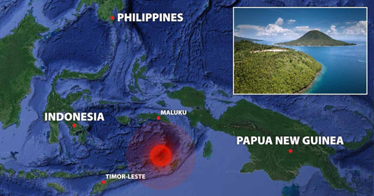
The epicentre was at 7.37° South Latitude and 130.23° East Longitude, or in the sea at 136 kilometres northwest of West South-eastern Maluku, and a depth of 130 kilometres.
BMKG confirmed that the tremor was felt in Saumlaki with an intensity of V Modified Mercalli Intensity Scale (MMI). Level V means it is felt by nearly everyone, many awakened, unstable objects are overturned, and pendulum clocks may stop.
The tremors were also felt in Dobo and Tiakur with an intensity of IV MMI; in Sorong, Kaimana, Alor, Waingapu, Waijelu, and Lembata with an intensity of III-IV; in Merauke, Nabire, Tanah Merah, Wamena, Bakunase, Kolhua, Sabu, Rote, Ende, South Amarasi and Kupang with an intensity of II-III MMI; as well as in Ambon and Piru with an intensity of II MMI.
The tsunami warning was issued at the alert status of Siaga (Watch) in Central Maluku, Southeast Maluku Islands, West Southeast Maluku Yamdena Island, and Ambon City; and at the alert status of Waspada (Caution) in Southeast Maluku, eastern Seram, western Seram, Buru, Wakatobi, Kendari Watulumango Island, Kendari Islands, southern Konawe, Kendari City, and Kendari.
No impacts on port operations have been reported. The Directorate General of Sea Transportation of the Ministry of Transportation ensured that the facilities and infrastructure at Maluku port were in good condition and safe after being shaken by a 7.5 magnitude earthquake that occurred in the early hours of Tuesday morning, January 10, 2023.