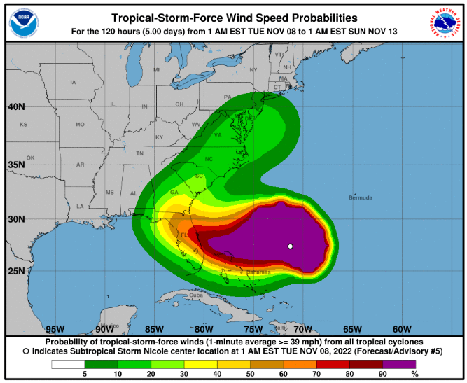
Hurricane conditions and a dangerous storm surge are expected in portions of the northwestern Bahamas on Wednesday, where a Hurricane Warning is in effect.
Hurricane conditions are possible across portions of the coast of southeast and east-central Florida beginning late Wednesday or Wednesday night, where a Hurricane Watch is in effect. Tropical storm conditions are expected in the Tropical Storm Warning areas in Florida and Georgia beginning early Wednesday.
A dangerous storm surge is expected along much of the east coast of Florida and portions of coastal Georgia where a storm surge warning is in effect. The storm surge will be accompanied by large and damaging waves. Residents in the warning area should listen to advice given by local officials.
Do not focus on the exact track of Nicole since it is expected to be a large storm with hazards extending well to the north of the center, outside of the forecast cone. These hazards are likely to affect much of the Florida peninsula and portions of the southeast U.S.
Nicole will produce heavy rainfall Wednesday and Thursday across the Florida Peninsula. Flash and urban flooding will be possible across portions of the Florida Peninsula along with renewed river rises on portions of the St. Johns River. Flash, urban and small stream flooding will be possible in southeast Georgia and portions of South Carolina Thursday into Thursday night.
SUMMARY OF 700 AM EST…1200 UTC…INFORMATION
———————————————-
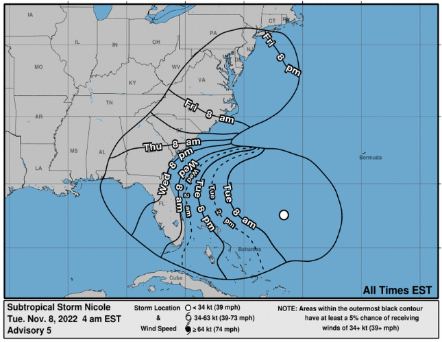
LOCATION…27.7N 72.0W
ABOUT 385 MI…615 KM ENE OF THE NORTHWESTERN BAHAMAS
MAXIMUM SUSTAINED WINDS…50 MPH…80 KM/H
PRESENT MOVEMENT…WNW OR 300 DEGREES AT 8 MPH…13 KM/H
MINIMUM CENTRAL PRESSURE…992 MB…29.29 INCHES
Port Conditions:
- Condition Whiskey (IV): The ALERT condition in which winds above 39 mph are expected within 72 hours.
- Condition X-Ray (III): The READINESS condition in which winds above 39 mph are expected within 48 hours.
- Condition Yankee (II): The WARNING condition in which winds above 39 mph are expected within 24 hours.
- Condition Zulu (I): The DANGER condition in which winds above 39 mph are expected within 12 hours and until the storm has passed and is no longer a threat.
Key West – OPEN – No Changes to operations
Miami – OPEN – YANKEE effective 0800/08th
*** Going to ZULU 2000/08th ***
Fort Lauderdale – OPEN – YANKEE effective 0800/08th
*** Going to ZULU 2000/08th ***
West Pam Beach – OPEN – YANKEE effective 0800/08th
*** Going to ZULU 2000/08th ***
Tampa – OPEN – No Changes to operations
Port Manatee – OPEN – No changes to operations
Port Canaveral – OPEN – XRAY effective 0800/08th.
Jacksonville – OPEN – WHISKEY effective 1600/07th.
Brunswick – OPEN – XRAY effective 1500/07th
Savannah – OPEN – XRAY effective 1500/07th
Charleston – OPEN – XRAY effective 2000/07th
Wilmington, NC – OPEN – No Changes to operations
Morehead City, NC – OPEN – No Changes to operations
Norfolk – OPEN – No Changes to operations
Inchcape Office Status:
Miami – Open
Tampa – Open
Jacksonville – Open
Savannah – Open
Charleston – Open
North Carolina – Open
Inchcape Office Status:
Miami – All staff are safe and accounted for as of 0800/08th.
Tampa – All staff are safe and accounted for as of 0800/08th.
Jacksonville – All staff are safe and accounted for as of 0800/08th.
Savannah – All staff are safe and accounted for as of 0800/08th.
Charleston – All staff are safe and accounted for as of 0800/08th.
North Carolina – All staff are safe and accounted for as of 0800/08th.