Please see below the latest on TROPICAL STORM IAN.
LANDFALL OCCURRED ON FLORIDA WEST COAST AT 1505/28TH.
STATE OF EMERGENCIES have been issued in Florida, Georgia, South Carolina, North Carolina & Virginia.
Major Disaster Declared in Florida.
Florida:
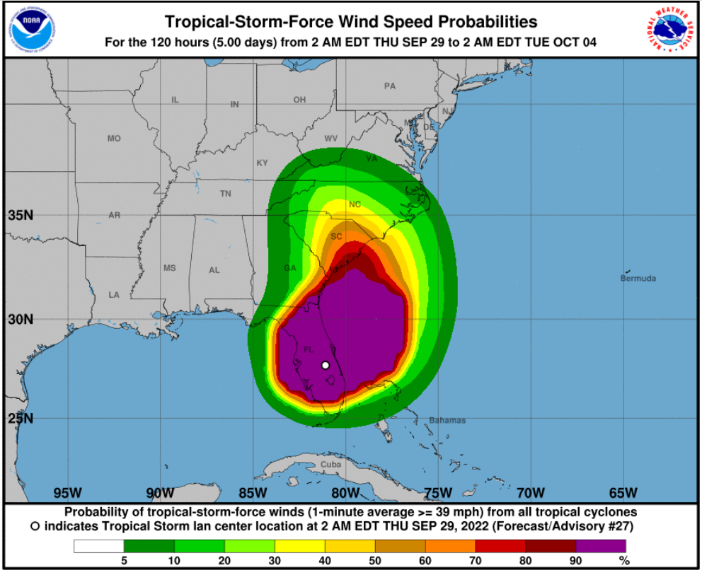
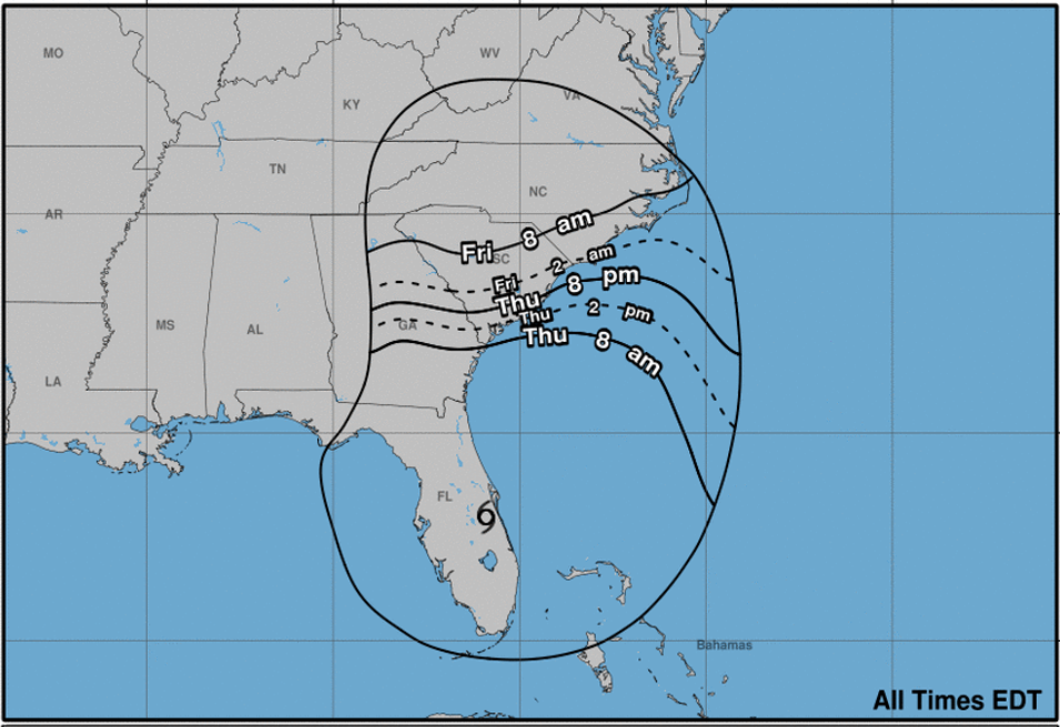
Hurricane IAN made landfall around CAYO COSTA, FLORIDA at 1505 EST September 28th. The eyewall of Hurricane IAN lasted over 5 hours showing how large and powerful this storm was. Hurricane IAN is currently TROPICAL STORM IAN (65 MPH winds) and travelling NE at 8 MPH across the Florida Peninsula. IAN is currently over central Florida, about 9 miles W of Cape Canaveral and is expected to continue on a NE path crossing the Florida Peninsula and departing Florida around the Daytona area. Once Ian departs Florida he is expected to take a N-NW turn and head towards Georgia/South Carolina.
Orlando and central Florida has many lakes and ponds so heavy flooding expected in areas at/near these bodies of water. Rainfall will determine whether mass flooding happens across the city.
Jacksonville areas along St Johns River and coastal cities along Atlantic Ocean from Fernandina (north of Jacksonville) South to Daytona expect heavy flooding. Rainfall will determine whether mass flooding happens across these cities.
Heavy Rainfall is still expected and the most heavy hit areas can expect over a foot of rain still.
Tampa Bay saw a Negative storm surge of 6’ from Hurricane IAN (Northeast Winds). Incoming water expected to rush back in which could cause flash/mass flooding in some areas.
Naples and Fort Meyers had Positive Storm Surges of 6’ & 7’+ feet which are now records for Florida in those 2 areas. Could take several days for waters to recede where flooding hits the worst.
Emergency workers will be limited in some of the hardest hit areas to get power and water back working due to flood waters.
Florida currently has 2.5 million people without power and that is expected to rise as storm crosses the state and affects 2 of the more populated cities in Orlando and Jacksonville. Power Restoration is expected to take several days to up to 2-3 weeks in some of the more hardest hit areas.
Full assessment of damage near landfall will not be able to be done until tomorrow morning.
Reports say fatalities are in the hundreds with numbers expected to rise although this is not fully confirmed yet. Bridges have had pieces collapse and roads have been swept away along coastal areas which will make traversing difficult on the West Coast areas for quite some time even after essentials (Water & Power) are restored.
Georgia:
Tropical Storm IAN based on center of projected cone is set to strike near Charleston SC Friday September 30th 1500-1700 approx.
IAN by the time he makes landfall a second time after passing over Florida Peninsula is expected to be Strong Tropical Storm but could strengthen to near Hurricane Category 1 again.
Ian is expected to bring high winds and heavy rain which could cause mass/flash flooding in the coastal Georgia areas affecting the ports of Brunswick and Savannah.
Strong storm surge is expected in Georgia Coastal areas.
Georgia updates will increase as Ian departs Florida.
South Carolina:
Tropical Storm IAN based on center of projected cone is set to strike near Charleston SC Friday September 30th 1500-1700 approx.
IAN by the time he makes landfall a second time after passing over Florida Peninsula is expected to be Strong Tropical Storm but could strengthen to near Hurricane Category 1 again.
Ian is expected to bring high winds and heavy rain which could cause mass/flash flooding in the coastal South Carolina areas affecting the port of Charleston.
Strong storm surge is expected in S. Carolina Coastal areas.
South Carolina updates will increase as Ian departs Florida.
North Carolina:
Tropical Storm IAN based on center of projected cone is set to strike near Charleston SC Friday September 30th 1500-1700 approx.
IAN by the time he makes landfall a second time after passing over Florida Peninsula is expected to be Strong Tropical Storm but could strengthen to near Hurricane Category 1 again.
Ian is expected to bring high winds and heavy rain which could cause mass/flash flooding in the coastal North Carolina areas affecting the ports of Wilmington & Morehead CIty.
Strong storm surge is expected in N. Carolina Coastal areas.
North Carolina updates will increase as Ian departs Florida.
Virginia:
Tropical Storm IAN based on center of projected cone is set to strike near Charleston SC Friday September 30th 1500-1700 approx.
IAN by the time he makes landfall a second time after passing over Florida Peninsula is expected to be Strong Tropical Storm but could strengthen to near Hurricane Category 1 again.
Ian is expected to bring high winds and heavy rain which could cause mass/flash flooding in the coastal North Carolina areas affecting the port of Norfolk.
Strong storm surge could be experienced in Virginia Coastal areas.
Virginia updates will increase as Ian departs Florida.
Advisory as of 0800 EST September 29th.
LOCATION…28.5N 80.7W
ABOUT 40 MI…70 KM E OF ORLANDO FLORIDA
ABOUT 10 MI…15 KM W OF CAPE CANAVERAL FLORIDA
MAXIMUM SUSTAINED WINDS…65 MPH…100 KM/H
PRESENT MOVEMENT…NE OR 35 DEGREES AT 8 MPH…13 KM/H
MINIMUM CENTRAL PRESSURE…987 MB…29.15 INCHES
Port Conditions:
• Condition Whiskey (IV): The ALERT condition in which winds above 39 mph are expected within 72 hours.
• Condition X-Ray (III): The READINESS condition in which winds above 39 mph are expected within 48 hours.
• Condition Yankee (II): The WARNING condition in which winds above 39 mph are expected within 24 hours.
• Condition Zulu (I): The DANGER condition in which winds above 39 mph are expected within 12 hours and until the storm has passed and is no longer a threat.
Key West – ZULU (Closed for business) – effective 2200 September 26th.
Miami – NORMAL – OPEN FOR BUSINESS. Expect ship movements in next couple hours to commence.
Fort Lauderdale – NORMAL – OPEN FOR BUSINESS. Expect ship movements in next couple hours to commence.
West Pam Beach – ZULU (Closed for business) – effective 1000 September 27th
Tampa – ZULU (Closed for business) – Effective September 27th.
Port Manatee – ZULU (Closed for business) – Effective September 27th.
Port Canaveral – ZULU (Closed for business) – Effective 0001 September 28th.
Jacksonville – ZULU (Closed for business) – Effective 1200 September 28th.
Brunswick – YANKEE – Effective 0001/28th / ZULU 1200/29th expected.
Savannah – YANKEE – Effective 0001/28th / ZULU 1200/29th expected.
Charleston – YANKEE – Effective 2000 September 28th / ZULU 1200/29th expected.
Wilmington, NC – No Condition – Open for Business / ZULU 1600/29th expected.
Morehead City, NC – No Condition – Open for Business / ZULU 1600/29th expected.