Please see below the latest on Hurricane IAN.
LANDFALL OCCURRED BETWEEN 15:05/28TH EST.
STATE OF EMERGENCIES have been issued in Florida, Georgia, South Carolina and North Carolina.
Florida:
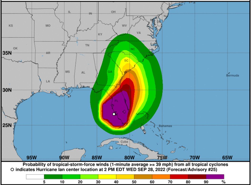
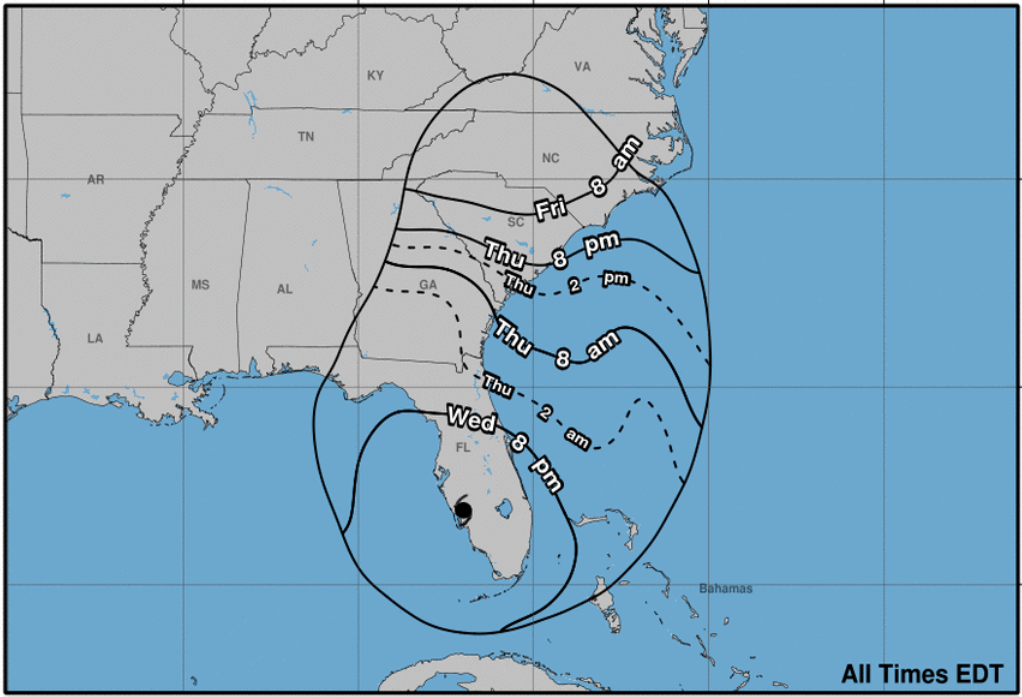
Hurricane IAN made landfall around CAYO COSTA, FLORIDA at 1505 EST September 28th. Hurricane IAN is currently a Category 2 Hurricane (100 MPH winds) and travelling NNE at 8 MPH across the Florida Peninsula. IAN is currently over central Florida, about 85 miles SW of Orlando and is expected to continue on a NNE path crossing the Florida Peninsula and departing Florida around the Daytona area. Once Ian departs Florida he is expected to take a N-NW turn and head towards Georgia/South Carolina.
Orlando and central Florida has many lakes and ponds so heavy flooding expected in areas at/near these bodies of water. Rainfall will determine whether mass flooding happens across the city.
Jacksonville areas along St Johns River and coastal cities along Atlantic Ocean from Fernandina (north of Jacksonville) South to Daytona expect heavy flooding. Rainfall will determine whether mass flooding happens across these cities.
Tampa Bay saw a Negative storm surge of 6’ from Hurricane IAN (Northeast Winds). Incoming water expected to rush back in which could cause flash/mass flooding in some areas.
Naples and Fort Meyers had Positive Storm Surges of 6’ & 7’+ feet which are now records for Florida in those 2 areas. Could take several days for waters to recede where flooding hits the worst.
Emergency workers will be limited in some of the hardest hit areas to get power and water back working due to flood waters.
Florida currently has 2 million people without power and that is expected to rise as storm crosses the state and affects 2 of the more populated cities in Orlando and Jacksonville. Power Restoration is expected to take several days to up to 2-3 weeks in some of the more hardest hit areas.
Full assessment of damage near landfall will not be able to be done until tomorrow morning.
Georgia:
Hurricane IAN based on center of projected cone is set to strike near the Georgia/South Carolina border.
IAN by the time he makes landfall a second time after passing over Florida Peninsula is expected to be Strong Tropical Storm/Low Category 1
Ian is expected to bring high winds and heavy rain which could cause mass/flash flooding in the coastal Georgia areas affecting the ports of Brunswick and Savannah.
South Carolina:
Hurricane IAN based on center of projected cone is set to strike near the Georgia/South Carolina border.
IAN by the time he makes landfall a second time after passing over Florida Peninsula is expected to be Strong Tropical Storm/Low Category 1
Ian is expected to bring high winds and heavy rain which could cause mass/flash flooding in the coastal South Carolina areas affecting the port of Charleston.
North Carolina:
Hurricane IAN based on center of projected cone is set to strike near the Georgia/South Carolina border.
IAN by the time he makes landfall a second time after passing over Florida Peninsula is expected to be Strong Tropical Storm/Low Category 1
Ian is expected to bring high winds and heavy rain which could cause mass/flash flooding in the coastal North Carolina areas affecting the ports of Wilmington & Morehead City.
Advisory as of 2000 EST September 28th.
SUMMARY OF 800 PM EDT…0000 UTC…INFORMATION
———————————————-
LOCATION…27.2N 81.7W
ABOUT 30 MI…50 KM NE OF PUNTA GORDA FLORIDA
ABOUT 95 MI…150 KM SSW OF ORLANDO FLORIDA
MAXIMUM SUSTAINED WINDS…115 MPH…185 KM/H
PRESENT MOVEMENT…NNE OR 20 DEGREES AT 8 MPH…13 KM/H
MINIMUM CENTRAL PRESSURE…960 MB…28.35 INCHES
Port Conditions:
- Condition Whiskey (IV): The ALERT condition in which winds above 39 mph are expected within 72 hours.
- Condition X-Ray (III): The READINESS condition in which winds above 39 mph are expected within 48 hours.
- Condition Yankee (II): The WARNING condition in which winds above 39 mph are expected within 24 hours.
- Condition Zulu (I): The DANGER condition in which winds above 39 mph are expected within 12 hours and until the storm has passed and is no longer a threat.
Key West – ZULU (Closed for business) – effective 2200 September 26th.
Miami – YANKEE – Effective 2000 September 27th.
Expect evaluations to reopen port to commence 29/am. Could resume by 1200/29
Fort Lauderdale – YANKEE– Effective 2000 September 27
Expect evaluations to reopen port to commence 29/am. Could resume by 1200/29
West Pam Beach – Yankee – effective 1100 September 26th
Expect evaluations to reopen port to commence 29/am. Could resume by 1200/29
- Tampa – ZULU (Closed for business) – Effective September 27th.
- Port Manatee – ZULU (Closed for business) – Effective September 27th.
- Port Canaveral – ZULU (Closed for business) – Effective 0001 September 28th.
- Jacksonville – ZULU (Closed for business) – Effective 1200 September 28th.
- Brunswick – YANKEE – Effective 0001/28th / ZULU 1200/29th expected.
- Savannah – YANKEE – Effective 0001/28th / ZULU 1200/29th expected.
- Charleston – YANKEE – Effective 2000 September 28th / ZULU 1200/29th expected.
- Wilmington, NC – No Condition – Open for Business / ZULU 1600/29th expected.
- Morehead City, NC – No Condition – Open for Business / ZULU 1600/29th expected.