Please see below the latest on HURRICANE IAN.
LANDFALL OCCURRED ON FLORIDA WEST COAST AT 1505/28TH.
DEPARTED FLORIDA AROUND 1200/29th
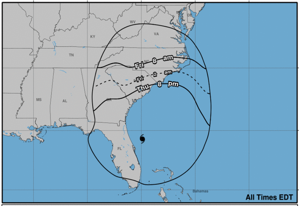
Second Expected Landfall near Charleston SC around 1400/30th
STATE OF EMERGENCIES have been issued in Florida, Georgia, South Carolina, North Carolina & Virginia.
Major Disaster Declared in Florida.
Hurricane IAN made landfall around CAYO COSTA, FLORIDA at 1505 EST September 28th. The eyewall of Hurricane IAN lasted over 5 hours showing how large and powerful this storm was.
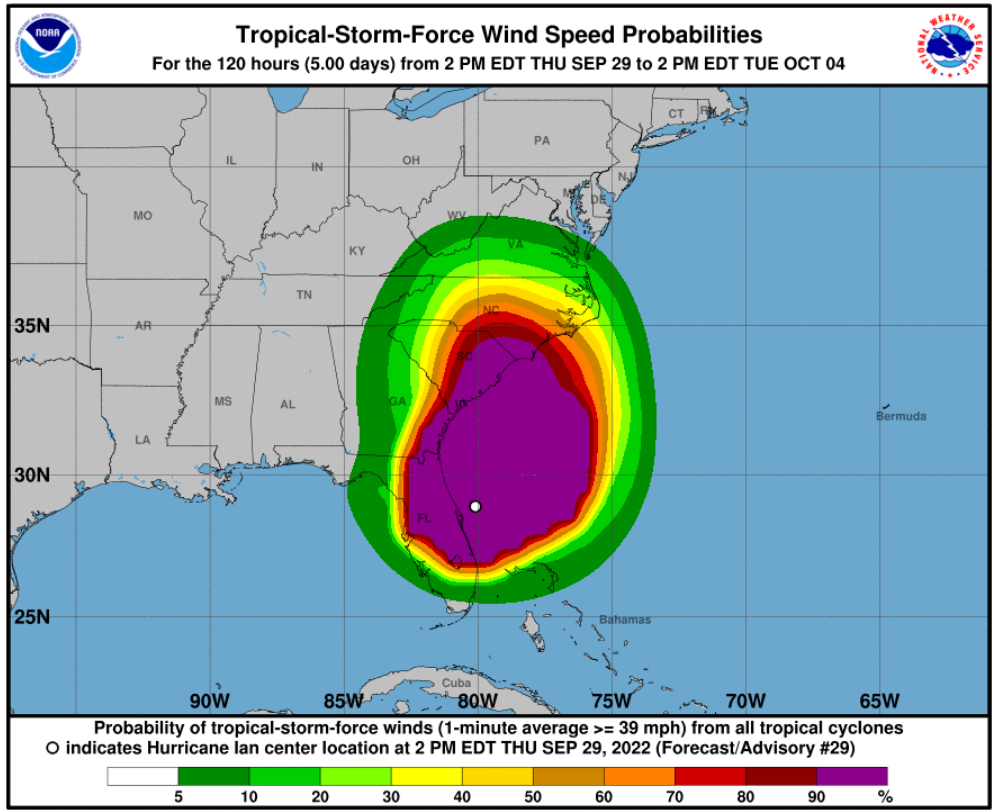
Hurricane IAN (Category 1 / 75 MPH) is currently travelling NNE at 10 MPH and is located 215 miles S of Charleston, South Carolina.
Hurricane IAN is expected to make landfall a second time around Charleston, SC.
Florida:
Hurricane IAN should be fully off of Florida around 2000-2300/29th.
Flood Threats still in affect for parts of NE Florida.
Much of Florida has experienced record rainfall, flooding and storm surges.
Parts of bridges and roads are destroyed in some of the hardest hit areas and this will limit the ability for emergency crews trying to check on citizens and/or restore essentials (Water and Electricity).
Unfortunately many deaths have already been confirmed and reports are death toll could be in the hundreds.
Florida currently has 2.6 million people without power and that is expected to rise as storm fully departs Florida and Jacksonville and cities just south of Jacksonville are no longer affected by TS IAN.
Power Restoration is expected to take several days to up to 2-3 weeks in some of the more hardest hit areas.
Lee and Charlotte Counties in Florida are completely off the grid and will be a complete rebuild which could be months before they are fully back up and running.
Full assessment of damage to Florida cities will take several days if not a week or more.
Curfews are in place in many cities throughout the state.
National Guard from Florida and 22 other states will be deployed to assist local authorities.
State and Federal Help and funding has been approved for the State of Florida.
Emergency Response crews for restoring power and water have been staged and crews re already starting the restoration process in parts of Florida.
Georgia:
Hurricane Warning for entire Georgia coast.
Strom Surge Warning for entire Georgia Coast.
Hurricane IAN based on center of projected cone is set to strike near Charleston SC Friday September 30th 1400-1600 approx.
IAN is expected to be a Hurricane Category 1 when he strikes S. Carolina.
Ian is expected to bring high winds and heavy rain which could cause mass/flash flooding in the coastal Georgia areas affecting the ports of Brunswick and Savannah.
Rainfall could be 6-12” or more in many areas.
Storm surge could be up to 7 feet along Georgia Coast.
South Carolina:
Hurricane Warning is in affect for entire S. Carolina Coast.
Storm Surge Warning for entire S. Carolina Coast.
Hurricane IAN based on center of projected cone is set to strike near Charleston SC Friday September 30th 1400-1600 approx.
IAN is expected to be a Hurricane Category 1 when he strikes S. Carolina.
Ian is expected to bring high winds and heavy rain which could cause mass/flash flooding in the coastal South Carolina areas affecting the port of Charleston.
Rainfall is expected to be 12” or more in hardest hit areas.
Storm surge could be up to 7 feet along S. Carolina Coast.
North Carolina:
Hurricane Warning is in affect for North Carolina Coast
Storm Surge Warning for entire North Carolina Coast.
Hurricane IAN based on center of projected cone is set to strike near Charleston SC Friday September 30th 1400-1600 approx.
IAN is expected to be a Hurricane Category 1 when he strikes S. Carolina.
Ian is expected to bring high winds and heavy rain which could cause mass/flash flooding in the coastal North Carolina areas affecting the ports of Wilmington & Morehead CIty.
Rainfall expected to be 6 – 12” or more
Storm surge could be 3-6 feet along N. Carolina Coast
Virginia:
Hurricane IAN based on center of projected cone is set to strike near Charleston SC Friday September 30th 1400-1600 approx.
IAN is expected to be a Hurricane Category 1 when she strikes S. Carolina.
Ian is expected to bring high winds and heavy rain which could cause mass/flash flooding in the coastal Virginia areas affecting the port of Norfolk.
Strong storm surge could be experienced in Virginia Coastal areas.
Advisory as of 2000 EST September 29th.
SUMMARY OF 800 PM EDT…0000 UTC…INFORMATION
———————————————-
LOCATION…29.7N 79.4W
ABOUT 215 MI…350 KM S OF CHARLESTON SOUTH CAROLINA
ABOUT 300 MI…485 KM SSW OF CAPE FEAR NORTH CAROLINA
MAXIMUM SUSTAINED WINDS…75 MPH…120 KM/H
PRESENT MOVEMENT…NNE OR 30 DEGREES AT 10 MPH…17 KM/H
MINIMUM CENTRAL PRESSURE…986 MB…29.12 INCHES
Port Conditions:
- Condition Whiskey (IV): The ALERT condition in which winds above 39 mph are expected within 72 hours.
- Condition X-Ray (III): The READINESS condition in which winds above 39 mph are expected within 48 hours.
- Condition Yankee (II): The WARNING condition in which winds above 39 mph are expected within 24 hours.
- Condition Zulu (I): The DANGER condition in which winds above 39 mph are expected within 12 hours and until the storm has passed and is no longer a threat.
Key West – OPEN with Restrictions
Miami – NORMAL – OPEN FOR BUSINESS.
Fort Lauderdale – NORMAL – OPEN FOR BUSINESS.
West Pam Beach – ZULU (Closed for business) – effective 1000 September 27th
Tampa – ZULU (Closed for business) – Effective September 27th.
Port Manatee – ZULU (Closed for business) – Effective September 27th.
Port Canaveral – ZULU (Closed for business) – Effective 0001 September 28th.
Jacksonville – ZULU (Closed for business) – Effective 1200 September 28th.
Brunswick – ZULU (Closed for business) – Effective 1200 September 29th
Savannah – ZULU (Closed for business) – Effective 1200 September 29th
Charleston – ZULU (Closed for business) – Effective 1200 September 29th
Wilmington, NC – ZULU (Closed for business) – Effective 1900/29th
Morehead City, NC – ZULU (Closed for business) – Effective 1900/29th
Norfolk, VA – ZULU (Closed for business) – Effective 0300/30th.